This section is the Classic Kaweah run. The description starts at the traditional historical Put in at Pumpkin Hollow Bridge even though the put in at the bridge has been blocked of in the spring of 1994. Put in below Headwall where the highway comes adjacent to the river. It's best to run this section with someone familiar with the run as some drops are hard to scout and the river splits in several places. The route is usually to the leftmost channel. This section is still runnable below zero on the gauge (less than 400 cfs) although it becomes quite technical and more rocks are visible than water.
Flood of Jan 97 Update: Nearly all the willows that blocked the channel are gone. The river is more readable as you boat it. The river is changed overall for the better, but rafters may disagree.
All photos taken at 0.5 ft on the Old Dinely Gauge (Approx 600 cfs in this section)
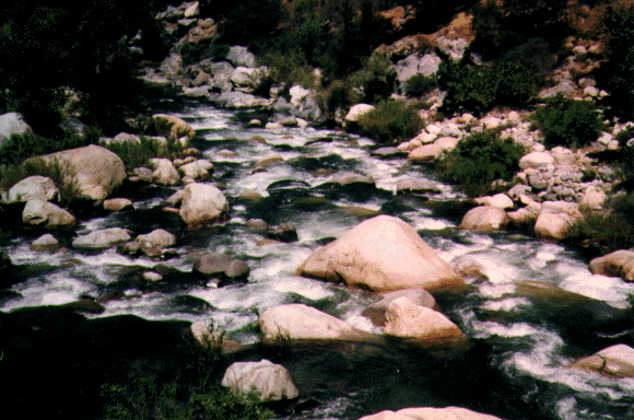 Gateway
Mile 0.0 GATEWAY (Class 4+)
250 yards steep boulder garden, many holes near bottom. Pool at bottom.
Flood of Jan 97 Update:The rapid is basically the same, but a few boulders have been moved around.
Mile 0.3 Unnamed (Class 3+)
Entrance rapid to the Chute. 200 yards to the Chute. Rapid continues right into The Chute.
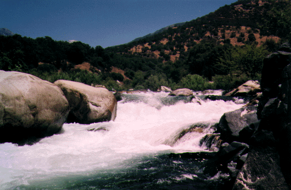 The Chute
Mile 0.5 THE CHUTE (Class 4)
Big 10 foot drop. Scout left at large rock outcropping on left. Run right center through huge crashing waves. Pool at bottom.
Flood of Jan 97 Update: The main drop has not changes, but the entrance has. What used to be a left to right tounge between 2 holes is now a river wide hole 30 feet before the main drop. The approach is now more from the right moving left. The right to left move at the top is despirate at 2.3 ft on the gauge.
Mile 0.6 Headwall (Class 3+)
Boulder strewn , ends at highway retaining wall. Holes center. Enter left, run left or right at exit. Pool at bottom.
Flood of Jan 97 Update: The upper half has been flattened out but the bottom half through the big boulders is the same.
![]() Osterizer,
the bottom half
Osterizer,
the bottom half
Mile 0.8 OSTERIZER (Class 4+)
1/4 mile pushy complex water, big holes center and right. Enter left or right, move left half way down to avoid large holes at exit. Scout left. Pool at bottom. This rapid is big water down the center at 2000cfs!
Flood of Jan 97 Update: The route is still down the left. Holes are bigger in the center and right. The holes at the exit extend all the way across the river and a far left exit is preferred. The large Piton Rock spews water at medium flows and above. Do not hit it at lower flows.
Mile 1.1 Unnamed (Class 3)
Short rapid with 3 medium rocks at top. Pool at bottom. Exit the pool through the first slot through the willows to the right.
Flood of Jan 97 Update: The small ledge playspot near the bottom of this rapid is now a large and wide hole. The willows are nearly all washed out at the entrance to the next rapid.
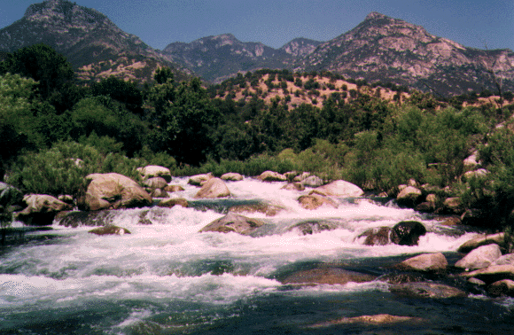
 Willows with
Alta Pk (11,200ft) in the background
Willows with
Alta Pk (11,200ft) in the background
Mile 1.3 WILLOWS (Class 4)
Long rapid studded with holes and hydraulics. A fun rapid.Flood of Jan 97 Update: The entrance is the same. Rocks have been moved around but it is still basically the same. The left side is easier. The willows that lined the rapid from top to bottom have been washed away on the left.
Mile 1.5 Krishna (Class 3)
Short rapid that ends at a 40 ft rock wall on right. Pool at bottom.Flood of Jan 97 Update: The piton rock at the exit has been replaced or eroded to where it is larger. Exit right or left of center.
Mile 1.6 Riverway (Class 3+)
Highway 60 feet above on left. 300 yard class 1 pool at bottom. This rapid becomes much more difficult above 3.0 ft on the gauge.Flood of Jan 97 Update: Pretty much the same. The ledge holes at the bottom seem bigger.
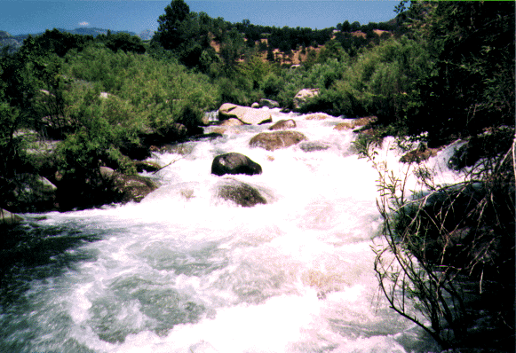
 Bumper
Mile 1.9 BUMPER (Class 4)
River drops 20 feet in 100 yards through big boulders and holes. Scout left. Enter left center, run left to avoid larger hole on the right.
Flood of Jan 97 Update: The rocks are in the same place but the holes are much bigger and stickier. There is a seldom run class 5 route down the far right channel that sports a tricky S turn move near the bottom.
Mile 2.6 Hammer (Class 3)
A right turn entrance down through some willows, then left.
Flood of Jan 97 Update: This rapid is improved. No willows and great whitewater all the way to Twin Treat. Ay low water be prepared for some rock dodging. The rocks come at you from out of nowhere.
Mile 2.6 Whiplash New Rapid (Class 2+)
Take the left channel after Bumper. It starts with 300 yards of class 1 in a new channel created by the flood of '97. Action picks up with the gradient and you may take a few willows across the face as you approach the top of Powerhouse at the left channel. It's best to be familiar with where you are going before taking this alternate route as there is no getting out to scout, and you want to run the left channel drop at Powerhouse on it's right side. There is no route back to the main river to run the conventional center channel at Powerhouse. Whiplash bypasses Twin Treat.Mile 2.3 Twin Treat (Class 3)
Pick your way down through the willows and make the left turn at the bottom. Channel splits with a hole on each side. Far left to avoid holes. Far right for largest hole. Large pool at bottom. A good pool to gather your composure for the rapid that�s next..
Flood of Jan 97 Update: The holes are on the left side now and have changed. The river has cut the main channel to the left of the old Twin Treat. Very little water flows in the old hole locations at low water.
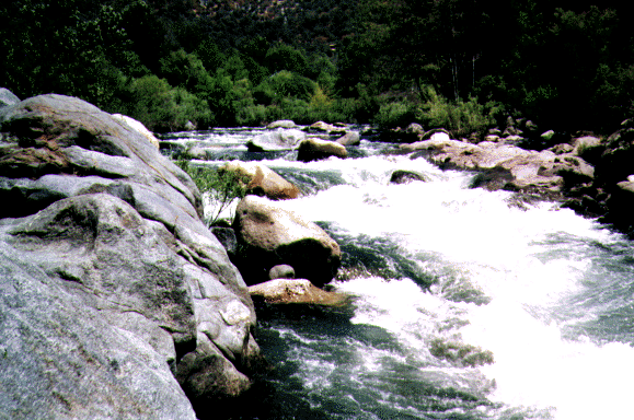
 Powerhouse
Mile 2.5 POWERHOUSE (Class 4+)
Hazardous drop. Scout from narrow island between right and center main channels. Run center channel by entering left or right of midstream boulder through willows and down the left side of the channel. Fast and shallow. Do NOT tip over in this rapid! Pin rocks at low water. Difficulty increases with lower flow. Consider portaging at very low water. 25 cfs is added to the river from SCE Powerplant No.1 on the left.
Flood of Jan 97 Update: There are still 3 channels. The center channel is still entered by going right of the black midstream rock (rock with a orange stripe) and the rapid is easier at the top, but 2 large rocks block the left side of the exit. The right most of the 2 rocks has been titled "The Janet Reno Piton Rock". Rafts routinely pin on these rocks at 1800 cfs and lower. Stay right at the exit. The far left channel is also runnable down it's right side by an approach through the willows. At low water Powerhouse is still a boat bashing descent. You're going to be hurting if you tip over. Scouting is now easier via beaching your boat on the island at the top and right of the center channel.
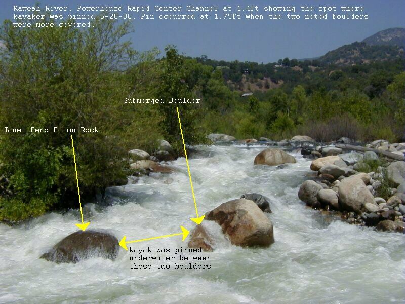
HAZARDOUS CONDITION ALERT! John Stockdell got pinned in Powerhouse 5-28-00 (gauge 1.75ft) on the Janet Reno Piton Rock at the bottom of the center channel. He was trying to exit the left side at the bottom of the drop and T-boned the rock and his boat slid sideways and broached between the Janet Reno Rock and a underwater rock left and upstream of that rock. The bow of his boat was angled to river right with the cockpit facing upstream. He reported that he had a small airpocket in front of his face as he was bent forward on the front deck but was able to free himself with not too much difficulty. He believes he washed under his pinned boat in the exit.. His 2 friends boating with him reported that John was completely underwater and out of sight during the ordeal. They were unable to free his boat that night but recovered the boat intact the next morning below Cyanotic. This is scary stuff! Let it be known that the center channel at Powerhouse is now known to be DANGEROUS and should carry a new level of respect. If you must run this drop please scout it and get right and exit the far right. Click to see where the pin occurred. Update: Powerhouse is even worse at 0.1ft on the gauge. Pinning is much more the possibility.
Mile 2.6 Unnamed (Class 3)
200 yard entrance rapid to Cyanotic.
 Cyanotic, the
upper half
Cyanotic, the
upper half
Mile 2.7 CYANOTIC (Class 4+)
300 yards of real action. Run top anywhere but eddy right or left at large rocks center and right. Ferry center and exit center or left. Right side ends in sieve at low flows but OK at high flows. At flows above 3.0 ft this rapid has serious penalty points for anything other than the perfect line. A very difficult scout from river left. Portage is impossible in rafts.
Flood of Jan 97 Update: The upper approach to Cyanotic has been flattened out and some of the bigger rocks are missing. The main drop midway down is pretty much the same. The left channel lower half of the rapid is the same but the right channel below the halfway point is now runnable via a boulder strewn approach or by running the far right channel from the top. The pin rocks at the right channel exit are gone.
Mile 2.9 Wedding (Class 3)
Fun and bouncy little 3. Pool at bottom, exit through left channel.Flood of Jan 97 Update: Wedding has been replaced with a new and better rapid on the far right bank. Take the far right channel just below Cyanotic. The new rapid features 2 sliding drops in a 30 foot wide bedrock channel. Old timers tell me this is the original channel before the great flood of 1955.
Mile 3.0 Macs (Class 3)
Rapid heads into rock wall on left and ends in pool with a house in the flood plane on river right.Flood of Jan 97 Update: The old rapid into the wall on river left is gone and the entire river channel is a major boat bashing gravel bar. Take the new route into Wedding and avoid being caught on the gravel bar.
Mile 3.1 Boink (Class 3)
Rapid turns left at dead tree on right. Bumpy entrance. Pool at bottom, exit out the left channel, down the Amazon Corridor.Flood of Jan 97 Update: This rapid is improved. The dead tree is gone and it has a more concentrated channel with good standing waves at the exit.
Mile 3.2 Screaming Right Turn (Class 3+)
Set up for hard right move at bottom to avoid the gnarly left side final drop.Flood of Jan 97 Update: There is no more Amazon Corridor. All the brush is gone. The left side exit drop is as gnarly as before. Stay right. There are some new holes just downstream. The far right channel of this rapid is also runnable at medium to high flows.
Mile 3.3 Elowin
More class 3's all the way to Dinely Bridge.Flood of Jan 97 Update: The rapids just above Dinely Bridge seem better.
Mile 3.3 Dinely Bridge
Gauge located on old bridge footing left. Take out on the right bank above the bridge.Look upstream at Park Boundary Section (Class 4)
Continue downsream Dinely Bridge to Three Rivers (Class 3+)

Copyright © 1996, 1997, 2000 by Bill Pooley. All rights reserved.
This page is http://www.c2.com/kaweah/log_gateway2dinely.html
Last modified: 07.03.00